
Between mountains and beaches. The Alpujarras and the murcian coast. It has been a while since we wanted to visit a zone of Spain that caught our attention: The Alpujarras granadinas and to complete the journey we wil go down to the coast and tour the nice and paradisiacal murcian coves.
Map with the route we performed.
Taking advantage of some days towards the end of December and coinciding with Christmas vacations, we get ready to enjoy some holiday days and to get to know a bit more about our great country. In this case we will go to the province of Granada and to the province of Murcia.
Parking at Vélez Blanco
Before we reach our main objective, we stop to know Vélez Blanco in the province Almería, which posseses an interesting architectonic set, as well as the cueva de los Letreros in its vicinity.
Parking at Vélez Blanco
We arrive at mid morning and park at the castle’s parking, at the top of the town, free and with no services. GPS: 37 41 24.61 N 2 05 55.81 W. It is divided in two parts, the one below is flatter and I thing can be a nice place to spend the night,
Parking and castle of Vélez Blanco.
As we have said, Vélez Blanco is a municipality of the province of Almería , even though because of its vicinity with the province of Murcia and above all Lorca, we get the impression that it almost seems to be more a town of Murcia than one of Andalucia.
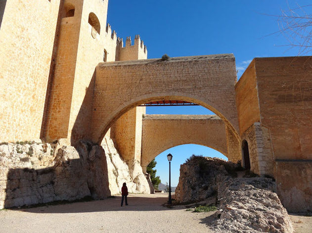
Castle of Vélez Blanco
This municipality of the district of Vélez has about 2,300 inhabitants and is situated at a considerable height, 1,070 meters, under the protection of the castle of the Fajardo, on the skirt of a mount that protects the town from the northern winds.
Castle of the Fajardo, Vélez Blanco
Evidently the main monument is the castle of the Fajardo from the XVI century, currently well restored and preserved. Built by Pedro Fajardo y Chacó, upon receiving the title of Marquis by the Catholic Kings, over the base of an ancient Islamic Citadel, it dominates the entire site with its imposing figure.
Vélez Blanco from the castle
The exterior along with the Weapons Courtyard can be visited without paying, but to access the interior of the castle one has to pay a symbolic fee which gives us the right to see the courtyard and some instances where there is an exhibit of photographs detailing the restoration works that were performed.
However the true jewel of the Castle was its courtyard from the renaissance which was sold in the beginning of the XIX century and which currently is exhibited in the Metropolitan Museum of New York, a shame.
To know more:
Castle of Vélez Blanco
Church of Santa María, Vélez Blanco.
After we were done touring the Castle through which it’s worth taking a peek if only because of the sights one can see from here of the town and the district, we descended by a path to the old part of the town.
Church of Santa María, Vélez Blanco
The castle is surrounded by a wall in some stretches not well preserved, we can also see the water well that supplied the castle, almost next to the walls of the church of Santa María.
Down the Castle’s street we reach the center of the town that today celebrates a weekly flea market.
Vélez Blanco
We are able to buy some cheese, some appetizers and dried fish of which we will take care of well in the car and we will remember more of this town.
Fuente de los cuatro caños, Vélez Blanco
While Mati entertains herself by the flea market, I get lost through the town alleys and I reach the zone of the creek which looks very nice, even though the surrounding area is somewhat in disrepair.
Vélez Blanco
Vélez Blanco and its castle
The morning is stupendous, it’s a joy to walk through the town, besides there is a Christmas ambiance and people in the streets. I pickup Mati to show her this part of the town and calmly we descend until we reach the lower portion of the town. In the summer this must be real good, with the zone full of vegetation.
Castle of Vélez Blanco
Besides, this part of the town is where one can see the best postcard view of the town perched on the hill’s skirt, it being crowned with the Castle of the Fajardo.
Vélez Blanco
This part of the town is called barranco de las Fuentes and it is a leisure area with gardens and strolling zones, even though it gives us the impression of being quite unkempt, they could get more out of this area if it was cleaner and better taken care of, even though regardless of that it is nice.
We keep wandering the streets and we can’t visit the Chuch of Santiago because it is closed, what a fad it is closing down monuments…
More information:
Vélez Blanco
We return to the car to head to the Cueva de los Letreros.
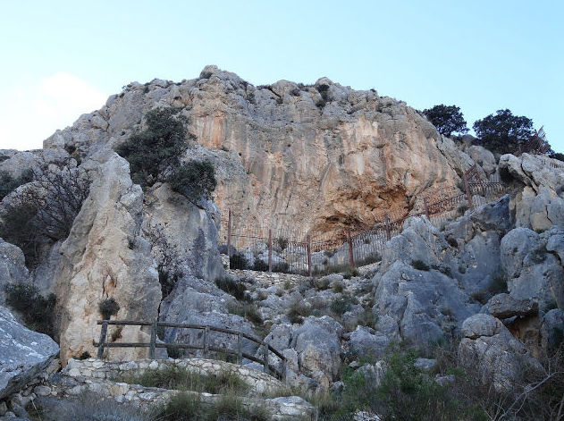
Access to the Cueva de los Letreros, Vélez Blanco
To visit the Cueva de los Letreros, which is really a shelter with cave paintings, one has to go to a sort of recreational zone in the outskirts of the town on the edge of the road and schedule a visit.
Even though there is no one on site, there is a phone number to get in touch.
More information:
Cueva de los Letreros GPS: 37 40 50.87 N 2 05 41.83 W
Access to the Cueva de los Letreros
We opted to head to the parking spot of the Cueva, eat and then afterwards to visit it, whether there is a programmed visit or not.
In front of this complex starts a dirt road that takes us to the Cueva. It’s almost better to leave the car at the coordinates of the complex but we want to be more isolated and we park in a widening of the road at the foot of the Cueva, besides there are some really nice sights from here.
Parking at the foot of the Cueva de los Letreros.
With a passenger car one can reach further up, but for a motorhome it is ill advised, since the road is in a state of disrepair and there is a rather large ramp,
Cueva de los Letreros
We start the ascent to the cave which in its last meters becomes a path with wooden walkways, even though the ascent to the Cueva is rather hard.
We reach the cave itself since to be able to see it one must schedule a visit, since there are fences that bar the access.
Cueva de Los Letreros
I was interested in seeing the famous Cueva de los Letreros where is located the famous figure of Indalo, symbol of the province of Almería, besides it has been declared as a World Heritage Site. But seeing it is a shelter and that from the outside one can’t see practically a thing, I was a bit disappointed and we went down to the car.
When we reach the bottom we see a couple going up to the Cueva since they have scheduled a visit, but we are too tired to go back up and we leave for Granada.
Detail of the place where we spent the night at Monachil
We reach the city of Granada and we are greeted by this universal monument they posses such as the Alhambra, already illuminated given the time of the day it is.
We try to find a spot to park near the center, to take a stroll through the city since there is a great ambiance, but we met a lot of traffic and traffic jams, so we left for Monachil.
Place where we spent the night at Monachil
We arrive to the town, which is located a few kilometers away from Granada and upon entering we see a sign that forbids parking caravans and motorhomes, a poor start, so we decide to go and spend the night in the parking spot of the Cahorros, to avoid troubles in the town.
Cahorros of Monachil
We arrive to the ample parking lot situated on the outskirts of the town,
GPS: 37 07 48.17 N 3 31 46.58 W
free and without services. We see that there is also a sign which forbids parking as well, even though someone has placed duct tape on the text as a form of protest. We think about it a while and we decide to spend the night there, in any case tomorrow we want to go down the route of the Cahorros and either way they can denounce us tonight or tomorrow morning.
The Cahorros
And here I must digress a bit. I can’t understand the harassment people who drive motohomes can suffer, as if we were pariahs without the same rights that any other driver has even though we pay the same taxes.
The Cahorros of Monachil
Besides here happens the double aggravating circumstance that parking is forbidden in all of the urban core for our vehicles, due to which we would have to spend the night in a camping site, up until this point I would agree. But if I spend the night in a camping site fattening the wallets of our real enemies, when I want to park to do the route of the Cahorros, very pretty by the way, where do I leave my vehicle, do I make it disappear, do I place it my pocket?
The Cahorros
In some place we had seen the prohibition of spending the night, but for them to forbid parking for 24 hours, it’s the worst, absurd and completely unfair and illegal. And from here, for whomever gets to read this, I advise against visiting this town, Monachil, enemy of motorhomers and despite it having the Cahorros, I will not come through here so long as they have not removed this unjust prohibition.
Suspension bridge of the Cahorros
We woke up and there wasn’t a complaint on our windshield. I have spent most of the night paying attention to see if I managed to hear some noise or having someone approach us to remind us we can’t park there, but we were lucky, now it remains seeing if whilst we were doing the hikers route we don’t end up being denounced
The Cahorros.
We loaded our backpacks and our walking sticks and after putting on winter clothes since it’s a bit cold, we get going to discover this zone that beforehand seems nice.
The Cahorros
It’s a bit early and we are the only ones visiting the path that takes us deeper into the Cahorros.
There are zones that prove somewhat difficult, when the walls grow narrower or are lower, forcing us to go through these zones squatting and in some even on our knees.
The Cahorros
We travel parallel to a stream, which makes us be more alert lest we slip which could make us bump ourselves and fall into the stream which at this time of the year must have water of a really low temperature.
The Cahorros of Monachil
In the time of the year we are in one can’t appreciate the real beauty of this place. I suppose that in any other season of the year it must be really nice, besides the temperature here during the summer must be very enjoyable, it must be a paradise, because the large stone walls must provide plenty of shade.
The Cahorros
Despite us expecting more of this route, probably because it is at the bottom of Sierra Nevada, we thought the route could maybe give more of itself, as if it was going to be a more mountainous route, perhaps.
The Cahorros.
We keep on going, until we see the route either starts an ascent to the high part of the mountain or the path we have been following ends.
The Cahorros.
Since we thought we have already walked a fair distance, we chose to follow the path that ascends higher up in the mountain and in this manner go to the parking spot.
The Cahorros.
Therefore, we ascend towards the part higher up and from this perspective one can see the Cahorros in a different way.
The Cahorros.
As we go up we receive the comforting solar rays of this morning that although it isn’t cold, below it was a bit chilly and here we already have to remove some clothes.
The Cahorros.
We stop for while to eat and drink something refreshing, since the temperature has gone up considerably.
It’s curious, but we haven’t seen anyone taking this route.
Return path from the Cahorros.
As we approach the parking spot, we do see groups of people venturing in to take the route, I think were the first taking the route today.
When we reach the parking spot we are happy to see that we weren’t denounced during our absence.
When we traverse again the town of Monachil we see several cars parked on the main street of the town, even though there were none last night.
Bridge Nazarí of Lanjarón.
We take the motorway A-44 heading for Lanjarón and when we see the sign that diverts us to that town we leave this highway and a bit later we stop on a beautiful nazarí bridge and right next to another modern bridge that crosses a ravine of substantial size.
Above bridge Tablate, Lanjarón.
We park next to a small chapel
GPS: 36 55 18.96 N 3 31 33.75 W
, called Virgen de las Angustias.
Rambla desde el puente Nazarí.
It is curious the fact that two bridges of different times are next to one another and that both of them fulfill their purpose perfectly, even though I choose the Nazarí one because of how pretty it is.
Nazarí bridge.
Our curiosity being sated, we leave this place and head for our nearby destination: Lanjarón.
Parking spot in Lanjarón.
We enter the town by the main street and make an initial contact with the town, which seems to have a nice ambiance, even though most hotels we see are closed, probably they are active in the summer.
Parking spot in Lanjarón.
I head for the parking spot, even though when we are about to enter there is a steep slope, and since we are going to be here a couple of hours, we decide not to tempt luck and we park in the road that goes around the town.
Parking of Lanjarón.
These are the coordinates of the dirt parking where we decided to park.
GPS: 36 55 03.10 N 3 28 49.29 W
And here is where we finally decided to park,
GPS: 36 55 01.57 N 3 28 49.02 W.
Square of Santa Ana, Lanjarón.
We go up to the town and we walk through the town’s main street. There’s ambiance and people on the streets.
Callecita de Lanjarón.
We do some shopping and after walking around for a while, we can’t get enough of Lanjarón. It indeed has potential, but it’s almost as if it was missing a push, perhaps this time of the year it isn’t at its best.
Square of Santa Ana, Lanjarón.
Until we discovered the lovely square of Santa Ana, a beautiful corner of Lanjarón that we like very much and where we seized the opportunity to sit down and contemplate how pretty this hidden place is.
Fountain in the Square of Santa Ana, Lanjarón.
Santa Ana Square, Lanjarón.
In this oasis of peace and tranquility, where there are no annoying noises, we stayed a while, accompanied by another foreign couple who have discovered this beautiful corner and are reluctant to leave.
Parking spot in Lanjarón.
Once again in the car, it is time to eat, so we keep on going and we will go and see if in the town’s outskirts there is a resting area that is visible from the town and where we will be able to park and eat.
Lanjarón from the leisure area.
Indeed, at around 2 or 3 kilometers in the road that took us to the Alpujarras there is a leisure area where we park and where we eat marvelously well.
Leisure area, Lanjarón.
Besides from this place one can admire perfect sights of Lanjarón and its mountain range.
GPS: 36 54 46.07 N 3 28 35.49 W.
Spending the night at Pampaneira.
Through twisting small roads but with good pavement we ascend meters little by little and finally we reach our first destination of the Alpujarras, Pampaneira.
Parking spot at Pampaneira.
In the town’s entrance there are two parking lots, one small which is where we will spend the night and a larger one right next to it,
GPS: 36 56 21.41 N 3 21 41.96 W.
Main parking lot of Pampaneira.
This parking is next to a smaller one separated by just a fence, though one must enter from the main street a bit upwards, through a somewhat narrow hole, but without any problems,
GPS: 36 56 22.96 N 3 21 43.13 W.
Typical products of the Alpujarras, Pampaneira.
There is little sun left and we take the opportunity to see some of the town.
We venture into the alleys full of tiny houses with their beautiful white facades, dotted with stores with products typical of the Alpujarras.
Pampaneira.
When one reaches this place, after several kilometers and through roads that seem to go directly to heaven, we allow ourselves to be surprised by the charms of this picturesque small town.
Typical Articles of Pampaneira.
The fact that there is no traffic in the streets is one of the things that we like the most when we see a place. Here it isn’t a matter of it being forbidden, it’s because one literally can’t drive through the urban core.
Nightfall at Pampaneira.
Little by little the sun sets, whilst we tour the intriguing and labyrinthine alleys of Pampaneira. We take the opportunity and make a short stop at a canteen where besides drinking some good wine with their corresponding tapa, we provision ourselves with some typical products.
Typical chimney of the Alpujarra.
A new day dawns. The night has been very quiet and we slept deeply.
The day is clear once again, and despite being December, the temperatures are very pleasant.
Today we go down a route through a path until Capileira passing through Bubión.
Bubión and the back of Sierra Nevada.
After having breakfast and preparing a mid morning sandwich, we go to the part of the town up top and we locate the path that goes underneath the road and which leads us to Bubión.
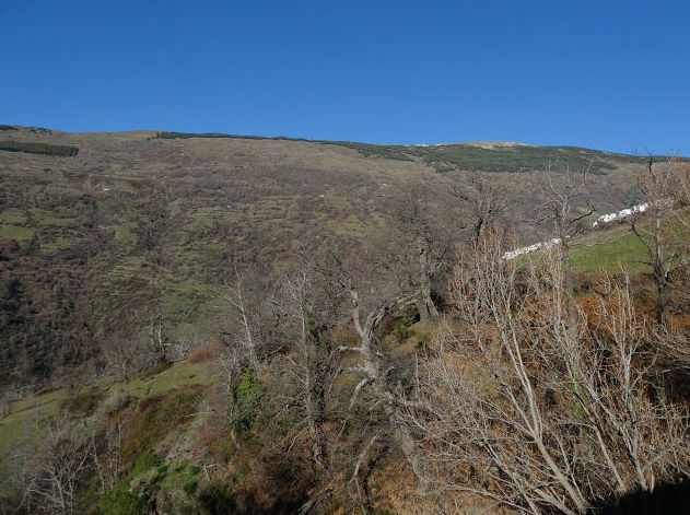
Landscape of the Alpujarras.
The degree of difficulty of the path is low, due to which we calmly go past the fields and forests which, despite being winter, are very beautiful.
Path to Bubión.
This place in the summer must be very beautiful, since there is a myriad of oaks and other species.
Oak leafs.
Centenarian oaks.
Old oaks from time to time show up in front of us, witnesses of history, they have reached our era and without a doubt have seen dawn and dusk for several generations of locals and travelers such as ourselves.
Parking situation in Capileira.
We make a stop beneath these oaks and have a snack in the most absolute tranquility, surrounded only by these magnificent specimens that seem to be dormant waiting to come back to life when the first heats of spring reach these hillsides.
Fountain at Bubión.
Parking spot of Capileira.
Through the path we take we access Bubión, when the temperature starts to seem more similar to that of spring than to that of winter.
We haven’t seen much ambiance still so we decide to check out the town when we descend and we keep going towards Capileira.
Parking spot at Capileira.
We see that these towns have managed to take advantage of the potential they have starting with the basics: the building of parking lots that make easier the complicated access to them.
Access to the parking spot at Capileira.
For that purpose they have built ample and easy parking zones. Specifically the one at Capileira is located here, GPS: 36 57 37.54 N 3 21 30.60 W.
Capileira.
Through the same path we leave Bubión and keep going up towards Capileira. At some point we lose our way, since the path isn’t outlined and we have to do the last meters following our instincts, even though we finally managed to get there.
Capileira.
Here there is indeed more ambiance, more people in the streets, more stores and businesses, etc. We seize the opportunity to rest having a coffee and once recovered we keep on going.
Capileira.
Our intention was to perform the route back through the lower part of the Poqueira ravine through a small path that takes us along the Poqueira river, but at the Tourism Office they informed us there has been a landslide and it has obstructed part of the path, so we will go back through another path that traverses the high part of town.
Capileira.
We finished seeing this typical town of Las Alpujarras, venturing into its alleys which are painted with an immaculate white color and beautifully adorned with plants and flowers.
Capileira.
We are in the low-season and there is a nice ambiance here, I don’t want to imagine what it must be like during the summer, perhaps a bit stressing.
Capileira.
After regaining our strength we go on the road once again and through the road that goes up to the Hoya del Portillo and we are able to see the parking spot for buses which can be a good alternative on where to spend the night, GPS: 36 57 36.89 N 3 21 19.80 W
Access to the Bus parking spot at Capileira.
Bus parking spot at Capileira.
We have only used the parking spot at Pampaneira, the town located below the valley and we have not needed the parking spots at Bubión and Capileira, since we wanted to do a route through the paths and in this manner to get to know these towns, but one can visit the three of them perfectly using the parking spots.
Capileira.
I had also considered the possibility of going up to the Hoya del Portillo where there is a picnic zone and from where different hiking routes emerge. One of them attracted me, the one of Mulhacén, but once I saw the state the road is in, I celebrate having desisted because its state of conservation is rather poor and with the car I think it would have been a mistake.
Sierra Nevada in the background.
Through a path, we started our return route after leaving the road behind. From up here one has magnificent sights of the entire Poqueira ravine and of the three towns that compose it.
Ravine of Poqueira.
The day couldn’t be better and the sights of the Sierra Nevada in the background make for a magnificent postcard.
Bubión in the background Capileira.
We are descending towards the road that joins the three towns and we reach Bubión to visit it since when we ascended early in the morning there was no ambiance at all.
State of the parking spot at Bubión.
This parking spot is the worst one of the three towns, since it is somewhat tilted and it is the smallest one, even though because of the proximity of the three towns there isn’t a problem with staying and sleeping in the one you prefer and to approach the towns using the others.
Parking spot at Bubión.
We get the feeling that of the three towns that constitute the valley, Bubión is the smallest one and may be the one with less to offer out of the three, but as I said, it’s just the feeling we get.
Another parking spot at Bubión next to the road.
Typical chimneys of Las Alpujarras.
The heat starts to rise and we fancy sitting down on a terrace and having a beer. We do this, even though we can’t stay for long since we have to retake the path that will lead us down to Pampaneira to eat and it is almost time to do so.
Church of Bubión.
Bubión.
We say goodbye to Bubión and at a faster pace than on the way up we spend a moment in Pampaneira, where we parked the car.
Pampaneira.
Yesterday, when we arrived, we almost didn’t have time to see the town because night fell, this morning the town brings us all of its beauty.
Pampaneira.
It may be the town we liked the most out of the three in this Valley, the one that has gotten to us the most and the prettiest one. As I said, these are just feelings we get.
Highly recommended tavern, Pampaneira.
We stop once again at the tavern from last night where we had chatted a long while with its likeable owner.
Pampaneira.
We reach the Square of Pampaneira where there is a very nice ambiance with people having tapas and eating in a relaxed manner.
Pampaneira.
After eating and resting for a while in the car, we decided to go on through the district and we left Pampaneira with a feeling of satisfaction having enjoyed these three pretty and peculiar towns of this zone of the province of Granada. They have fulfilled completely our expectations.
Parking spot at Pórtugos.
Our next destination is Trevelez where we will stop to sleep, but before we have to see the small towns and areas the GR-421 shows us, this being the road we are driving through.
Parking spot at the Fuente Agria de Pórtugos.
We go through the town of Pórtugos and in the beginning it doesn’t seem too interesting so as to make a stop, with the other 3 towns we have had enough already and this one doesn’t seem like the other ones, even though we do stop at its ferrous fountain.
Fuente Agria, Pórtugos.
On the way out of the town and at its edge there is a small hermitage and a leisure zone with a parking spot where we leave the car and we get out to see the Fountain.
Fuente Agria, Pórtugos.
These are the coordinates of the parking spot: GPS: 36 56N 25.60 N 3 18 22.91 W. the fountain is right there, travelling down a path.
Fuente Agria, Pórtugos.
Well, the place is curious. To see how the water has formed the riverbed of the stream into reddish colored dirt, as well as the scent of iron one can breathe there, it’s curious.
Fuente Agria, Pórtugos.
I grab an empty bottle and I fill it with this cloudy water and Mati stops me from drinking, distrustful of the properties of the water, even though I can’t resist and I wet my lips a little, evidently it’s a flavor I had never tasted before.
Fuente Agria, Pórtugos.
It’s okay as a curiosity and since it is in the way a small stop there is advisable.
We keep on going down our route towards Trevelez by the same road which is in good shape though a bit narrow.
Place to spend the night at Trevelez.
We arrive to Trevelez not stopping anywhere almost at nightfall and we join an ample parking spot in the high part of town.
Parking spot at Trevelez.
These are the coordinates of the parking spot: GPS: 37 00 07.51 N 3 16 07.01 W. free and without services, ample and quiet, one can only hear the impetuous waters of the river.
Parking spot at Trevelez.
Also next to it there is a bar where we can have a drink, something we will do later on.
Further down below there is another esplanade in which we see three cars parked, though it’s probably not as calm as this parking spot
The other parking spot at Trevelez.
The coordinates of this parking spot are as follows:: GPS: 36 59 55.78 N 3 15 52.92 W. situated in the Square of Barrio Bajo.
Trevelez.
We take a stroll around the town imagining we would discover something similar to the other 3 towns we visited previously, but we did not find it. We just find a town that seems to be almost exclusively devoted to the elaboration and sale of products derived from swine.
Sights of Trevelez.
Everywhere one can see stores and sheds where they produce sausages and hams, the famous hams from Trevelez. We go into one of these stores and buy some sausage. Even though, as I said, the town itself doesn’t have much to show, truly a small disappointment.
Castle of Santa Ana, Roquetas de Mar.
This morning we are trading the mountain for the beach, more specifically that of Murcia, so we set off towards that place.
When going past these Roquetas de Mar, Mati fancies making a stop to see a bit of this well known tourism town, so we do that.
Lighthouse at Roquetas de Mar.
We park near the castle of Santa Ana and after shopping around we visited the zone of the castle and the beach.
Castillo de Santa Ana, Roquetas de Mar.
After this pause we followed the route by the Nacional 340 which runs parallel to the sea and goes past really nice places.
We are looking for a place to eat at and we find it.
Tropical Beach, La Garrofa.
We go past Aguadulce and a short while after we find a charming place where to stop for a bit and eat next to the sea calmly, the Tropical Beach of Palmer. GPS: 36 49 25.45 N 2 31 36.94 W.
Place where we stopped to eat.
The day is marvelous and it’s a pleasure to be here next to the sea.
El Palmer Beach.
We eat calmly accompanied by another foreign car with a stupendous view of the sea. It’s in moments like this when one is grateful for travelling in this manner.
El Palmer Beach.
After a relaxing nap we keep on going towards our next destination: the murcian coast.
San Juan de los Terreros.
We make an initial stop at San Juan de los Terreros, when the sun is reaching its end for the day, so we take the chance to see the sun set.
Parking spot at San Juan de los Terreros.
We park in a zone of dirt with a bit of a slope., GPS: 37 21 29.32 N 1 39 56.75 W, even though there are signs that forbid spending the night, something that doesn’t seem to bother another 3 or 4 mhs that are going to spend the night there.
San Juan de los Terreros.
We take a stroll through the zone of the town that is next to the beach and it seems to us that this is another one of these places that must be really nice during the summer and which this time of the year is depressing, almost no one being here.
San Juan de los terreros.
It’s something that repeats itself not just here, but in many other places of the levantine coast.
Parking spot.
Nightfall at San Juan de los Terreros.
Since the place we are at doesn’t convince us completely we leave in search of a more appropriate place to spend the night, something we find at the Beach of the Cocedores, near Aguilas.
Spending the night at Beach of the Cocedores.
We reach a large esplanade a few meters away from the beach of the Cocedores where there are plenty of motorhomes parked, most of them foreign.
Beach of the Cocedores.
These are the coordinates of the parking spot: GPS: 37 22 32.78 N 1 37 46.68 W, free and without services and with no signs that forbid spending the night, a highly recommended place.
Beach of the Cocedores.
We have dinner and after watching TV for a while we lay down without hearing but a sound.
In the morning we get a better view of where we spent the night and the amount of cars that concentrate here, a true motorhome paradise.
Cocederos Beach and Aguilas in the background.
Calnegre Beach.
We reach the Calnegre Beaches and park at the edge of a small cove, GPS: 37 30 25.11 N 1 24 59.79 W, right at the edge of the sea.
Cove of Calnegre.
We leave our car here and go down the path to take a small hikers route enjoying these charming corners and coves.
Cove of the Women.
The landscape is very pretty, volcanic with a black color that impregnates everything and gives it that peculiar and characteristic character.
Cove of Siscal.
We reach a larger cove, Siscal. I am in the mood to keep on going for a while longer, but Mati prefers to rest and wait for my return.
Cove of Siscal.
You can reach this place on a vehicle, as matter of fact there are several cars parked, I imagine during the summer this must be a hotbed due to how pretty it is.
Landscape at Coves of Calnegre.
I follow a path that belongs to the one signaled as a hikers route and at one point I take a route that leads me straight to the sea and I go back to the Cove of Siscar through the cliffs of the beach.
Landscape of the Coves of Calnegre.
When I reach the place where I left Mati I don’t see her and I imagine that she must have gone back to the car, since there is no coverage, I go to where we parked the car.
Sights of the Coves of Calnegre.
When I reach the car, I don’t see Mati, so she must be at the Cove of Siscar, so I go there again but with the car. I don’t recommend driving through here with the car, due to the great slopes the road has.
Parking spot at Puntas de Calnegre.
After the reunion and the typical discussion of me being there and you didn’t see me, that I passed through and you weren’t there, etc, etc.
Well, we kept on going since we have to eat and in one of the beaches in the outskirts of Puntas de Calnegre.
Cars at Puntas de Calnegre.
Here there is a veritable legion of cars, almost all foreign. GPS: 37 31 28.83 N 1 23 29.80 W.
Here we remain whilst we eat and relax for a while.
Parking spot at Puntas de Calnegre.
We continue our trip and make the following stop at Bolnuevo in my opinion hostile to motorhomes, clear if you don’t stop at the camping here.
Parking spot at Bolnuevo.
We reach the immense and huge parking spot there is in this town and we see they have installed some large signs prohibiting caravans and motorhomes.
Curious formations at Bolnuevo.
When I reach a place like this and see that the camping imposes their rules so that everyone has to go through their gate, I get nervous, I get pieced off and the first thing I think of is to get out of here as soon as I can.
GPS: 37 33 49.51 N 1 18 43.26 W.
Signs prohibiting parking.
But I have learned already that no one can condition us at their whim, so we must be wittier than these people and go around them, for that purpose we parked in a street hidden from the view of any Agents that might be tempted to enforce such an unfair traffic regulation.
Sand formations at Bolnuevo.
After seeing the curious sand formations in the parking spot itself, we take a stroll down the beach and drink something at a terrace.
Gredas of Bolnuevo.
We passed by the camping that is located next to the beach in a privileged place their clients being mostly older foreign people.
Erosions and prohibitions at Bolnuevo.
The town doesn’t have much more to give. As a geological curiosity, the erosion of the sandy rocks is interesting, but they can be quickly seen and given the way in which we are welcomed, I advice to keep going and to stop where they at least let you park.
Erosion effect at Bolnuevo.
Bolnuevo
That is what we did and we decided to drive to the nearby location of Puerto de Mazarrón to spend the night there.
Location of the place where we spent the night at Puerto de Mazarrón.
Spending the night at El Puerto de Mazarrón.
We parked at a free parking spot near the beach, GPS: 37 33 39.11 N 1 16 03.50 W.
Since it is still early we take a stroll up to the dock where we go into a tea shop and have some delicious tea.
Puerto de Mazarrón.
Here there is more of an ambiance, you see people in the streets since despite being in mid December the temperature is very pleasant.
Island of Mazarrón.
We spend the night calmly and face the final day of our Christmas trip of 2012.
Today we are going to see a curious zone in the vicinity of Cartagena, specifically at Cabo Tiñoso.
Bay of Cartagena.
We are going to visit a set of abandoned installations of the Spanish army positioned in a strategic place conceived so that given the eventuality, they could defend the important bay of Cartagena from possible incursions by another country.
Panoramic of the zone.
To reach the top one must arm oneself with courage, because to drive along this road with a motorhome isn’t the most advisable thing, but with care one can reach the destination trouble free.
Parking spot at Batería del Atalayón.
Finally we reach the parking spot at Castillitos, but due to being careless I become disoriented and I take the road that goes up to the batería del Atalayón, big mistake.
Informative panel at Batería del Atalayón.
Those who come here should not make the same mistake I made, because the access is dangerous and once you are up top there is no way out, one must maneuver around and turn very carefully.
Out of service site.
Once we have made the mistake of getting up here, we visit the ruins of what back in its day must have been a site worth checking out.
Another perspective of the site.
One can see the different offices, warehouses, ammunition and armament deposits, etc. of this complex system of anti aircraft defense, truly it’s worth it.
Parking spot at Castillitos.
We descend slowly to the parking spot to finish seeing all of this GPS: 37 32 28.16 N 1 07 34.46 W, where there is an esplanade and from what we can see one can spend the night there since there is a motorhome that must have spent the night there, since its passengers come out naked just after waking up oblivious to the presence of other people.
Castillitos.
We will finish seeing this site and the one at Castillitos is the better preserved one and more interesting, since it also has two truly impressive anti aircraft guns and of a huge size.
Up top one can see the Atalayón battery.
From here one can see up top where we just drove up and down with the car, my God, so crazy. Surely Mati will remind me of this later…
Castillitos.
Well, calling this place Castillitos seems evident right? When they designed the place they did so thinking of a castle with its towers and battlements, truly it is nice, not the typical sober military facility.
Central body of Castillitos.
The thing that impresses me the most of this site is the human work that must have taken to bring up here all of the material to make this possible and the amount of soldiers that must have been in service here in this remote place.
Anti aircraft gun.
We can see the two anti aircraft guns of considerable size, as well as paintings on the wall of the type of boats of the time by country that presumably could approach our shores.
Engravings with the different boats of the time.
The construction of this enclave was made to perfectly mimic this environment and I think they were very careful and detailed, I think so that it would be more difficult to recognize from the air.
View of this set.
There is another third location further ahead, the Batería de Jorel, that is in the point of Cabo Tiñoso, but we can’t see it because Mati isn’t passionate about this kind of thing and I settle with having seen two out of three places that constitute this strategic framework.
Sights of the Bay of Cartagena from Castillitos.
We are not alone in this visit, there are other people that are interested in this subject strange as it may seem, besides the sights from here of the entire bay are magnificent.
Anti aircraft of gun of Castillitos.
Battery of Jorel in the background.
To know more:
Anti aircraft guns of Castillitos
We set out for home and in the vicinity of Cartagena we go past a town called Canteras which I didn’t know existed, but upon seeing a sign pointing out an ancient roman quarry I could not resist the temptation and we stopped to see it.
Roman quarry.
They are not very well pointed out and there is a lack of information, but we finally find them, GPS: 37 36 52.90 N 1 02 37.04 W.
Roman quarry.
They are impressive. These walls are perfectly cut and they remind me of the slabs of soap my mother made when I was a child.
Roman quarry.
For a moment I am transported to roman times and I imagine the workers of this mine extracting stones for the construction of the monuments of Cartago Nova, nowadays Cartagena.
Roman quarry.
I recently read the trilogy of Santiago Posteguillo about the life of the roman General Publio Cornelio Escipión, El Africano, who took Cartagena from the Carthaginians and seeing a quarry from which the material used to build the city could have come from is exciting and gratifying to those who are fond of that epoch.
With this final and pleasant surprise we set off for home which we reach without hindrances and wanting to prepare our next trip which will be no doubt next Easter.